Mile-by-Mile Whitewater Rafting Guide for the Lower Klamath
The Happy Camp to Dillon Creek section is merely a 23 mile section of the 100 mile stretch of the Lower Klamath. This is the most popular section of the river but whitewater rafting trips can be extended by putting in up higher and taking below the Happy Camp section. The rapids listed below have an approximate mileage and level of difficulty. Have a good trip!!
Mile 0: Put-In: Curly Jack Campground (downstream of Happy Camp)
Mile 1.7: Wounded Knee (class II)
Mile 3.0: Rattlesnake (class III)
Mile 3.7: Devil's Toenail (class III)
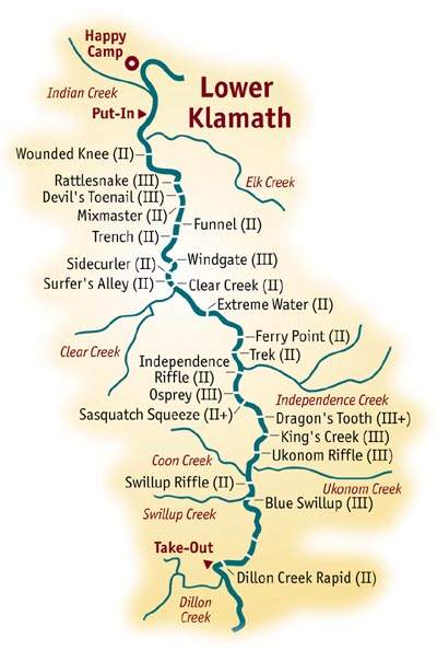 Mile 4.3: Mixmaster (Class II)
Mile 5.1: Funnel (class II)
Mile 5.8:Trench (class II).
Mile 6.6: Windgate (class III)
Mile 7.0: Sidecurler (class II).
Mile 7.3: Surfers Alley (class II)
Mile 7.5: Clear Creek (class II)
Mile 8.9: Extreme Water (class III)
Mile 10.2: Ferry Point (class II)
Mile 11.0: Trek (Class II).
Mile 12.0: Independence Riffle (class II)
Mile 13.6: Osprey (class III)
Mile 14.2 Sasquatch Squeeze (class II+)
Mile 15.4: Dragon's Tooth (class III+)
Mile 16.1 King's Creek (class III)
Mile 16.7: Ukonom Riffle (class III)
Images courtesy of All-Outdoors California Whitewater
Rafting
Mile 18.0: Swillup Riffle (class II)
Mile 18.9: Blue Swillup Riffle (class III)
Mile 19.7: Elliott Creek enters on the right.
Mile 22.3: Dillion Creek Rapid (class II)
Mile 22.7: Take-Out: Dillion Creek Campground